Munger Trail Hinckley to Willow River
The Munger Trail is one of Minnesota's premier rails to trails and the primary trail connector for a trip from Duluth to Minneapolis. At this point it connects Duluth to Hinckley and the next trail begins at North Branch, but hopefully they will be connected at some point.
The previous review of this trail went from Willow River to Moose Lake. This covers the southern most stretch of the trail 22 miles from Hinckley to Willow River. The trail begins next to the active rail tracks on the north side of the community and not on the casino side.


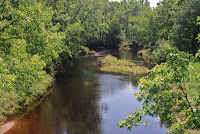
 The Hinckley Fire of 1894 is the historic context of Hinckley - the railroad and highway 61, the fish hatchery and the Grindstone river make for an interesting and beautiful beginning.
The trail is flat and straight as you leave Hinckley and peddle north. This area was the shoreline of old glacial lake Grantsburg and has bogs and marshlands that fill the old basin.


An interesting stop to relax is skunk lake, a small water body that was responsible for saving many people and wild animals as the train tried to get the victims out of the burning town.

 There were good stretches of blackberries and the woods had least flycatchers, pewees, and vireos singing as I went by. Friesland, Miller Junction, and Groningen were trail junctions that led towards Finlayson - all absent from the state map now, but railroad developments during the 19th century.
 The beaver lodge on the left was on one of the wetland complexes from Sandstone junction to Finlayson. Veery calls in the woods, yellowthroat, yellow warbler, and golden winged warblers near wetlands. Red winged blackbirds, marsh wrens, and kingbirds in the marshes.
Finlayson has a beautiful wetland on the east side that often has black terns and the small town has a Clark station where you can get refreshments.


 Leaving Finlayson there is a large gravel area where the mining has removed a glacial esker and you will approach the only hilly section of the southern half of the trail. The railroad grade goes through farm property so the trail skirts the fields and goes up and down and around a few curves that makes the ride really interesting (and a little exhausting). In this area we have seen bear, wolves, fox, skunk, rabbit, and beaver.
When the trail straightens out again on the old rail bed it passes large marshes where you might hear bitterns and then crosses the Pine River.


 Next the trail passes the town of Rutledge and crosses the Kettle River and then moves in to the Willow River sand plain where native prairie dominates. Here are chipping sparrows, catbirds, song sparrows and vesper sparrows plus wonderful summer flowers, but be careful - there is a lot of poison ivy.
Then on to Willow River.


The previous review of this trail went from Willow River to Moose Lake. This covers the southern most stretch of the trail 22 miles from Hinckley to Willow River. The trail begins next to the active rail tracks on the north side of the community and not on the casino side.


 The Hinckley Fire of 1894 is the historic context of Hinckley - the railroad and highway 61, the fish hatchery and the Grindstone river make for an interesting and beautiful beginning.
 The trail is flat and straight as you leave Hinckley and peddle north. This area was the shoreline of old glacial lake Grantsburg and has bogs and marshlands that fill the old basin.


An interesting stop to relax is skunk lake, a small water body that was responsible for saving many people and wild animals as the train tried to get the victims out of the burning town.


Finlayson has a beautiful wetland on the east side that often has black terns and the small town has a Clark station where you can get refreshments.


 Leaving Finlayson there is a large gravel area where the mining has removed a glacial esker and you will approach the only hilly section of the southern half of the trail. The railroad grade goes through farm property so the trail skirts the fields and goes up and down and around a few curves that makes the ride really interesting (and a little exhausting). In this area we have seen bear, wolves, fox, skunk, rabbit, and beaver.
When the trail straightens out again on the old rail bed it passes large marshes where you might hear bitterns and then crosses the Pine River.


 Next the trail passes the town of Rutledge and crosses the Kettle River and then moves in to the Willow River sand plain where native prairie dominates. Here are chipping sparrows, catbirds, song sparrows and vesper sparrows plus wonderful summer flowers, but be careful - there is a lot of poison ivy.
Then on to Willow River.


Nice write up! I've often wondered why the stretch south of Rutledge doesn't follow the old railway grade. Do you know why? Most likely it was a land acquisition problem, but why?
ReplyDeleteHello! I realize this is a long shot, but I'm looking for a good photo of the Grindstone Dam to use on my news website St. Croix 360 (stcroix360.com). Yours is lovely, is there any chance I could use it with credit? Thanks! Feel free to email at greg@stcroix360.com.
ReplyDelete