Posts

Showing posts from June, 2012

Sandstone

Image
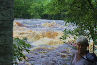
The flood waters have left the Moose Horn and the upper Kettle.  Willow River now has a dry main street and the homes in Rutledge are being cleaned and dried, but the water is still moving.  At Banning State Park the Rapids are ferocious.  The water is moving rapidly through this canyon, but the walls confine the spread and concentrate the energy in the middle.  Where it is interrupted the water piles upon itself until it finds places where it can get out of the banks and release the energy. Below Sandstone it flows over Hidden Falls, a waterfall that had been covered up by a dam for over 30 years.  Two days ago the water was so high that there were no falls; today the lowering water showed some of the drop. We had our daughter-in-law, Kristin and our Granddaughter Teagan along with us on our exploration. A stop in Sandstone to get groceries presented the opportunity to support the local PTO by purchasing brats and burgers outside of Chris' Fairway. Then home

Itasca

Image
Because of the floods our trip to Itasca became one day instead of two and we had to drive south from Willow River to get around the closed roads and bridges to find a route we could use to go west.  This took us around Lake Mille Lacs, over to Brainerd, then up to Walker and on to Itasca. There I received the first Lifetime Achievement Award from the Minnesota Association of Environmental Education (MAEE). This was an amazing honor and wonderful recognition from my peers. The event was held at the Mary Gibbs Center in Itasca State Park - the headwaters of the Mississippi River and an important part of our 2013 expedition. Lake Itasca is shaped like a slingshot and the river drains out of the north end over a series of slippery stepping stones.  It is hard to envision the small stream that exits the lake to be the same river as the industrial waterway we saw near New Orleans. The Mississippi starts in the true north - land of red and white pines and Minnesota's st

Willow River to Rutledge - HWY 61 in flood

Image
While Duluth was getting its 8 inch rain storm, the Northern Pine County area was getting 4.  Duluth had devastating results and much worse than Pine County, but traveling by bike along hwy 61 today was a lesson in how disasters extend beyond the immediate storm. As the waters up north move south, they find a land saturated by the late May and Early June rains with rivers swollen by the 4 inch rain.  Then the south flowing waters join the Kettle and the damage intensifies. Moose Lake in Carlton County is closed - the Moosehorn flooded on both ends of town and further north Barnum has its bridges flooded over so Moose Lake is essentially an island.  The Moosehorn waters flowing south then build up the Kettle River and it meets its tributaries to make a dangerous and exciting scene.  It is both awful and beautiful. The Kettle River swollen with the Moose Horn and other tributaries is the source of the water covering the town and when it meets other rivers - it i

Munger Trail Hinckley to Willow River

Image
The Munger Trail is one of Minnesota's premier rails to trails and the primary trail connector for a trip from Duluth to Minneapolis.  At this point it connects Duluth to Hinckley and the next trail begins at North Branch, but hopefully they will be connected at some point. The previous review of this trail went from Willow River to Moose Lake.  This covers the southern most stretch of the trail 22 miles from Hinckley to Willow River.  The trail begins next to the active rail tracks on the north side of the community and not on the casino side.  The Hinckley Fire of 1894 is the historic context of Hinckley - the railroad and highway 61, the fish hatchery and the Grindstone river make for an interesting and beautiful beginning.  The trail is flat and straight as you leave Hinckley and peddle north.  This area was the shoreline of old glacial lake Grantsburg and has bogs and marshlands that fill the old basin. An interesting stop to relax is skunk lake, a small water body th